Recent searches
Loading...
1359-1064 - Detail of sculpture named Piss made by David Cerny, Lesser Quarter, Prague
1382-254 - seabirds Tropicbirds,Pajaros Islet also named Swan's Cay off the coast of Boca del Drago on Colon Island,Bocas del Toro Archipelago,Republic of Panama,Central America
1382-253 - Pajaros Islet also named Swan's Cay off the coast of Boca del Drago on Colon Island,Bocas del Toro Archipelago,Republic of Panama,Central America
1382-200 - young waitress presenting a famous cake named Sakotis in a decorated version at Romnesa bakery-restaurant at Strigailiskis, Ignalina district, Aukstaitija National Park, Lithuania, Europe
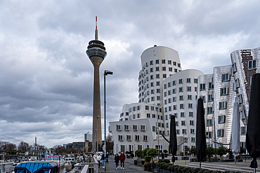
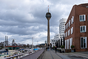
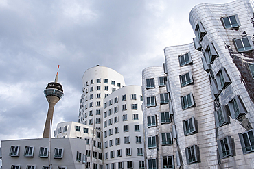
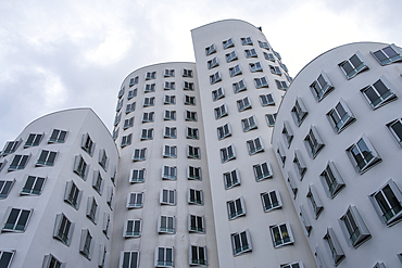
1373-330 - View of the Neuer Zollhof (The New Zollhof, named after a former customs facility), a prominent landmark of Düsseldorf-Hafen, part of the redeveloped port of Düsseldorf, Germany with the Rheinturm (Rhine Tower) telecommunications tower in the background.
1373-328 - View of the Neuer Zollhof (The New Zollhof, named after a former customs facility), a prominent landmark of Düsseldorf-Hafen, part of the redeveloped port of Düsseldorf, Germany with the Rheinturm (Rhine Tower) telecommunications tower in the background.
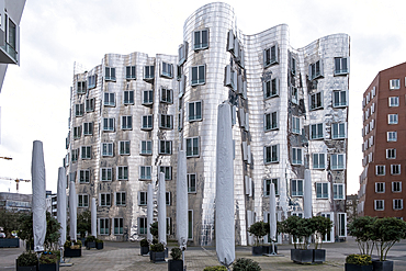
1373-323 - View of the Neuer Zollhof (The New Zollhof, named after a former customs facility), a building ensemble in Düsseldorf's “Medienhafen” and a prominent landmark of Düsseldorf-Hafen, part of the redeveloped port of Düsseldorf, Germany
1373-324 - View of the Neuer Zollhof (The New Zollhof, named after a former customs facility), a prominent landmark of Düsseldorf-Hafen, part of the redeveloped port of Düsseldorf, Germany with the Rheinturm (Rhine Tower) telecommunications tower in the background.
1373-322 - View of the Neuer Zollhof (The New Zollhof, named after a former customs facility), a building ensemble in Düsseldorf's “Medienhafen” and a prominent landmark of Düsseldorf-Hafen, part of the redeveloped port of Düsseldorf, Germany
1373-321 - View of the Neuer Zollhof (The New Zollhof, named after a former customs facility), a building ensemble in Düsseldorf's “Medienhafen” and a prominent landmark of Düsseldorf-Hafen, part of the redeveloped port of Düsseldorf, Germany
1358-361 - Mourning Dove (Zenaida macroura),a member of the dove family, Columbidae, named after its mournful call, Bermuda, North Atlantic, North America
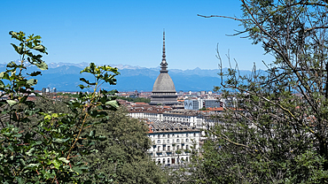
1373-146 - Cityscape of Turin, Italy, featuring the iconic Mole Antonelliana building that stands out among the city's skyline. This landmark is named after its architect, Alessandro Antonelli. In Italian, a “mole” refers to a building of monumental proportions.
1373-140 - Cityscape featuring the iconic landmark Mole Antonelliana building named after its architect, Alessandro Antonelli, Turin, Piedmont, Italy, Europe
1373-138 - View of the Mole Antonelliana, a major landmark, named after its architect, Alessandro Antonelli, Turin, Piedmont, Italy, Europe
1372-56 - Green grass with a white goat named Yuki sitting next to its red hut and beautiful volcanic panorama of snowy volcano, Yotei-zan, Hokkaido, Japan, Asia
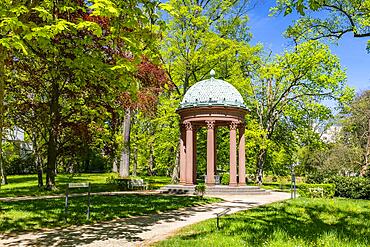
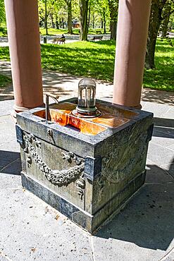
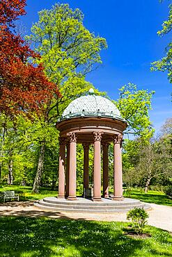
832-400749 - Elisabethenbrunnen, named after Princess Elisabeth, woman of Landgrave Friedrich VI of Hesse-Homburg and daughter of the British King George III, in the spa garden Bad Homburg vor der Hoehe, Hesse, Germany, Europe
832-400747 - Elisabethenbrunnen, named after Princess Elisabeth, woman of Landgrave Friedrich VI of Hesse-Homburg and daughter of the British King George III, in the spa garden Bad Homburg vor der Hoehe, Hesse, Germany, Europe
832-400748 - Elisabethenbrunnen, named after Princess Elisabeth, woman of Landgrave Friedrich VI of Hesse-Homburg and daughter of the British King George III, in the spa garden Bad Homburg vor der Hoehe, Hesse, Germany, Europe
832-400746 - Auguste Viktoria Fountain, named after the woman of Kaiser Wilhelm II, in the spa gardens of Bad Homburg vor der Hoehe, Hesse, Germany, Europe
832-400745 - Auguste Viktoria Fountain, named after the woman of Kaiser Wilhelm II, in the spa gardens of Bad Homburg vor der Hoehe, Hesse, Germany, Europe
832-400744 - Auguste Viktoria Fountain, named after the woman of Kaiser Wilhelm II, in the spa gardens of Bad Homburg vor der Hoehe, Hesse, Germany, Europe
832-400743 - Auguste Viktoria Fountain, named after the woman of Kaiser Wilhelm II, in the spa gardens of Bad Homburg vor der Hoehe, Hesse, Germany, Europe
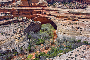
1311-652 - The Kachina Bridge, named for the Hopi Kachina dancers, Natural Bridges National Monument, Utah, United States of America, North America
1359-947 - Artwork named Idiom designed by Matej Kren in 1998, a book tunnel of 8000 books at the Municipal Library of Prague, Prague, Czech Republic (Czechia), Europe
832-399265 - Menton, France - circa August 2021: view of the French Riviera, named the Coast Azur, located in the South of France
832-399263 - Menton, France - circa August 2021: view of the French Riviera, named the Coast Azur, located in the South of France. Sunrise light
832-399260 - Menton, France - circa August 2021: view of the French Riviera, named the Coast Azur, located in the South of France. Sunrise light
832-399257 - Menton, France - circa August 2021: view of the French Riviera, named the Coast Azur, located in the South of France. Sunrise light
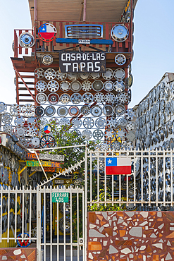
1359-734 - House decorated with car wheel covers named Casa de las Tapas, Cerro Bellavista, Valparaiso, Valparaiso Province, Valparaiso Region, Chile, South America
83-13363 - Mantled Howler Monkey (Alouatta palliata), named for its call, eating leaves in tree, Nosara, Guanacaste Province, Costa Rica, Central America
83-13361 - Mantled Howler Monkey (Alouatta palliata), named for its call, eating leaves in tree, Nosara, Guanacaste Province, Costa Rica, Central America
1350-6678 - Strawberry Poison Frog (Dendrobates pumilio), adult, Bastimentos National Park, Bocas del Toro, Panama. The strawberry poison frog or strawberry poison-dart frog (Oophaga pumilio or Dendrobates pumilio) is a species of small amphibian poison dart frog found in Central America. It is common throughout its range, which extends from eastern central Nicaragua through Costa Rica and northwestern Panama. The species is often found in humid lowlands and premontane forest, but large populations are also found in disturbed areas such as plantations. The strawberry poison frog is perhaps most famous for its widespread variation in coloration, comprising approximately 15���30 color morphs, most of which are presumed to be true-breeding. O. pumilio, while not the most poisonous of the dendrobatids, is the most toxic member of its genus. The species is most diverse in Panama with varieties in vivid shades of all red, orange, blue, yellow or green, green and yellow, white with red, orange or black and spotted varieties. The most colorful mix is found in Isla Bastimentos Marine National Park though not all in one place. Colors vary by location. A beach on the north side of the island is named after the species. Two of Southern Explorations' Panama tours visit red frog habitat. Both the eight-day Panama Adventure trip and eleven-day Panama Highlights trip spend time in Isla Bastimentos Marine National Park and the former also goes to Red Frog Beach.
The red frog is not as poisonous as some of its cousins and is not a threat to humans. It subsists on a diet of ants that dine on poisonous plants, providing the red frog its protective skin toxin. Males attract females with a loud quick chirp. To hear the distinctive sound before you depart on your Panama tours, go to the University of Michigan Museum's biodiversity website (www.animaldiversity.ummz.umich.edu.) After birth, the tadpoles climb aboard the mother who deposits them in different protected areas where she retu
450-4586 - Bicycle buggy named Ferrari going down a cobblestone street, Trinidad, Cuba
1311-567 - An area of the Red Basin in Petrified Forest National Park Arizona where the purple bentonite transitions into red for which the basin is named.
1359-167 - Street art named Abuelita aburrida (Bored grandma) by artists Ella & Pitr, Cerro Alegre, Valparaiso, Chile
1359-143 - Historic building named Solnice on Piaristicke namesti at twilight, Ceske Budejovice, South Bohemian Region, Czech Republic
1359-70 - Popular rock formation (hoodoo) named Thor's Hammer taken from Navajo Loop Trail, Bryce Canyon National Park, Utah, USA
1359-56 - Famous giant sequoia tree named Grizzly Giant, Mariposa Grove, Yosemite National Park, California, USA
1311-335 - Keyhole Mesa, named for a keyhole shaped cave on its north side, in the First Forest of Petrified Forest National Park, Arizona, United States of America, North America
1336-210 - Orange sunset named enrosadira on Catinaccio mountain, Val di Tires, Bolzano, Italy, Europe
1336-211 - Winter pink sunset named enrosadira on Catinaccio mountain with snow and a wooden fence, Carezza, Bolzano, Italy, Europe
1336-5 - Sunset light on the Italian badlands named Calanchi, Emilia Romagna, Italy, Europe
149-1104 - Memorial before the Royal Albert Hall, built in 1871 and named after Prince Albert, Queen Victoria's consort, Kensington, London, England, United Kingdom, Europe
1112-4860 - The seven storeyed Palace named Vijayotpaya, Polonnaruwa, UNESCO World Heritage Site, Sri Lanka, Asia
1112-4859 - The seven storeyed Palace named Vijayotpaya, Polonnaruwa, UNESCO World Heritage Site, Sri Lanka, Asia
849-1847 - Shitennoji Temple, named after the four heavenly kings of Buddhist tradition, Osaka, Japan, Asia
849-1840 - Shitennoji Temple, named after the four heavenly kings of Buddhist tradition, Osaka, Japan, Asia
849-1836 - Shitennoji Temple, named after the four heavenly kings of Buddhist tradition, Osaka, Japan, Asia
1304-33 - An abandoned and ruined train station named Grasplatz in the town Luderitz within the Spergbeit Diamond Region, Namibia, Africa
83-13085 - Rambutans, a popular tropical fruit named after the Malay word for hairy, Central Market, city centre, Phnom Penh, Cambodia, Indochina, Southeast Asia, Asia
857-95963 - Barren landscape and art named Spiral Jetty designed by Robert Smithson, Spiral Jetty, Utah, USA
1113-102805 - Wooden red bridge named Shinkyo over river Daiya in Nikko, Tochigi Prefecture, Japan
1113-102806 - Wooden red bridge named Shinkyo over river Daiya in Nikko, Tochigi Prefecture, Japan
1116-40092 - Hawaiian Green Sea Turtle (Chelonia mydas) named 'Honu', Makena, Maui, Hawaii, United States of America
1116-40091 - Hawaiian Green Sea Turtle (Chelonia mydas) named 'Honu';Makena, Maui, Hawaii, United States of America
1116-40090 - Hawaiian Green Sea Turtle (Chelonia mydas) named 'Honu', Makena, Maui, Hawaii, United States of America
1116-40089 - Hawaiian Green Sea Turtle (Chelonia mydas) named 'Honu', Makena, Maui, Hawaii, United States of America
1131-1074 - Chapel and Gautama Buddha, Cultural Center Ruh Ordo named after Chinghiz Aitmatov, Issyk Kul Lake, Cholpon-Ata, Kyrgyzstan, Central Asia, Asia
1131-1073 - Gavroche statue, Ruh Ordo Cultural complex named after Kyrgyz writer Chinghiz Aitmatov, Issyk Kul Lake, Cholpon-Ata, Kyrgyzstan, Central Asia, Asia
1131-1078 - Ruh Ordo Cultural complex named after famous Kyrgyz writer Chinghiz Aitmatov, Issyk Kul Lake, Cholpon-Ata, Kyrgyzstan, Central Asia, Asia
1131-1077 - Balbal, Sculpture, Cultural Center Ruh Ordo named after Kyrgyz writer Chinghiz Aitmatov, Issyk Kul Lake, Cholpon-Ata, Kyrgyzstan, Central Asia, Asia
805-1128 - The Silver Pavilion, named because of moonlight reflecting on its dark wood walls, in Ginkakuji Zen temple garden, Kyoto, Japan, Asia
857-94471 - Named ?Paivan Kakkara? in Finnish, a daisy bush is illuminated by the midnight sun in early July in central Finland.
857-94717 - Nimoa Island - here the island mission will impress. The five-sided church features murals of island life and all mission buildings are surrounded by well maintained paths and gardens filled with flowering plants. Edged by jungle-covered mountains, postcard beaches and crystal clear waters - an island paradise indeed! The Louisiade Archipelago is a string of ten larger volcanic islands frequently fringed by coral reefs, and 90 smaller coral islands located 200 km southeast of New Guinea, stretching over more than 160 km and spread over an ocean area of 26,000 km? between the Solomon Sea to the north and the Coral Sea to the south. The aggregate land area of the islands is about 1,790 km? (690 square miles), with Vanatinai (formerly Sudest or Tagula as named by European claimants on Western maps) being the largest. Sideia Island and Basilaki Island lie closest to New Guinea, while Misima, Vanatinai, and Rossel islands lie further east. The archipelago is divided into the Local Level Government (LLG) areas Loui!
857-94720 - Nimoa Island - here the island mission will impress. The five-sided church features murals of island life and all mission buildings are surrounded by well maintained paths and gardens filled with flowering plants. Edged by jungle-covered mountains, postcard beaches and crystal clear waters - an island paradise indeed! The Louisiade Archipelago is a string of ten larger volcanic islands frequently fringed by coral reefs, and 90 smaller coral islands located 200 km southeast of New Guinea, stretching over more than 160 km and spread over an ocean area of 26,000 km? between the Solomon Sea to the north and the Coral Sea to the south. The aggregate land area of the islands is about 1,790 km? (690 square miles), with Vanatinai (formerly Sudest or Tagula as named by European claimants on Western maps) being the largest. Sideia Island and Basilaki Island lie closest to New Guinea, while Misima, Vanatinai, and Rossel islands lie further east. The archipelago is divided into the Local Level Government (LLG) areas Louisiade Rural (western part, with Misima), and Yaleyamba (western part, with Rossell and Tagula islands. The LLG areas are part of Samarai-Murua District district of Milne Bay. The seat of the Louisiade Rural LLG is Bwagaoia on Misima Island, the population center of the archipelago.
857-94718 - Nimoa Island - here the island mission will impress. The five-sided church features murals of island life and all mission buildings are surrounded by well maintained paths and gardens filled with flowering plants. Edged by jungle-covered mountains, postcard beaches and crystal clear waters - an island paradise indeed! The Louisiade Archipelago is a string of ten larger volcanic islands frequently fringed by coral reefs, and 90 smaller coral islands located 200 km southeast of New Guinea, stretching over more than 160 km and spread over an ocean area of 26,000 km? between the Solomon Sea to the north and the Coral Sea to the south. The aggregate land area of the islands is about 1,790 km? (690 square miles), with Vanatinai (formerly Sudest or Tagula as named by European claimants on Western maps) being the largest. Sideia Island and Basilaki Island lie closest to New Guinea, while Misima, Vanatinai, and Rossel islands lie further east. The archipelago is divided into the Local Level Government (LLG) areas Louisiade Rural (western part, with Misima), and Yaleyamba (western part, with Rossell and Tagula islands. The LLG areas are part of Samarai-Murua District district of Milne Bay. The seat of the Louisiade Rural LLG is Bwagaoia on Misima Island, the population center of the archipelago.
857-94722 - Children playing with a outrigger canoe in the village of Hessessai Bay at PanaTinai (Panatinane)island in the Louisiade Archipelago in Milne Bay Province, Papua New Guinea. The island has an area of 78 km2. The Louisiade Archipelago is a string of ten larger volcanic islands frequently fringed by coral reefs, and 90 smaller coral islands located 200 km southeast of New Guinea, stretching over more than 160 km and spread over an ocean area of 26,000 km? between the Solomon Sea to the north and the Coral Sea to the south. The aggregate land area of the islands is about 1,790 km? (690 square miles), with Vanatinai (formerly Sudest or Tagula as named by European claimants on Western maps) being the largest. Sideia Island and Basilaki Island lie closest to New Guinea, while Misima, Vanatinai, and Rossel islands lie further east. The archipelago is divided into the Local Level Government (LLG) areas Louisiade Rural (western part, with Misima), and Yaleyamba (western part, with Rossell and Tagula islands. The LLG areas are part of Samarai-Murua District district of Milne Bay. The seat of the Louisiade Rural LLG is Bwagaoia on Misima Island, the population center of the archipelago.PanaTinai (Panatinane) is an island in the Louisiade Archipelago in Milne Bay Province, Papua New Guinea.
857-94715 - Nimoa Island - here the island mission will impress. The five-sided church features murals of island life and all mission buildings are surrounded by well maintained paths and gardens filled with flowering plants. Edged by jungle-covered mountains, postcard beaches and crystal clear waters - an island paradise indeed! The Louisiade Archipelago is a string of ten larger volcanic islands frequently fringed by coral reefs, and 90 smaller coral islands located 200 km southeast of New Guinea, stretching over more than 160 km and spread over an ocean area of 26,000 km? between the Solomon Sea to the north and the Coral Sea to the south. The aggregate land area of the islands is about 1,790 km? (690 square miles), with Vanatinai (formerly Sudest or Tagula as named by European claimants on Western maps) being the largest. Sideia Island and Basilaki Island lie closest to New Guinea, while Misima, Vanatinai, and Rossel islands lie further east.
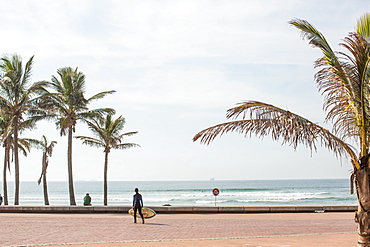
857-94999 - A boy with a surfboard walks down the promenade on the Golden Mile - named for its stretches of golden sand beaches - Durban, South Africa.
857-94719 - Nimoa Island - here the island mission will impress. The five-sided church features murals of island life and all mission buildings are surrounded by well maintained paths and gardens filled with flowering plants. Edged by jungle-covered mountains, postcard beaches and crystal clear waters - an island paradise indeed! The Louisiade Archipelago is a string of ten larger volcanic islands frequently fringed by coral reefs, and 90 smaller coral islands located 200 km southeast of New Guinea, stretching over more than 160 km and spread over an ocean area of 26,000 km? between the Solomon Sea to the north and the Coral Sea to the south. The aggregate land area of the islands is about 1,790 km? (690 square miles), with Vanatinai (formerly Sudest or Tagula as named by European claimants on Western maps) being the largest. Sideia Island and Basilaki Island lie closest to New Guinea, while Misima, Vanatinai, and Rossel islands lie further east. The archipelago is divided into the Local Level Government (LLG) areas Louisiade Rural (western part, with Misima), and Yaleyamba (western part, with Rossell and Tagula islands. The LLG areas are part of Samarai-Murua District district of Milne Bay. The seat of the Louisiade Rural LLG is Bwagaoia on Misima Island, the population center of the archipelago.
857-94721 - Nimoa Island - here the island mission will impress. The five-sided church features murals of island life and all mission buildings are surrounded by well maintained paths and gardens filled with flowering plants. Edged by jungle-covered mountains, postcard beaches and crystal clear waters - an island paradise indeed! The Louisiade Archipelago is a string of ten larger volcanic islands frequently fringed by coral reefs, and 90 smaller coral islands located 200 km southeast of New Guinea, stretching over more than 160 km and spread over an ocean area of 26,000 km? between the Solomon Sea to the north and the Coral Sea to the south. The aggregate land area of the islands is about 1,790 km? (690 square miles), with Vanatinai (formerly Sudest or Tagula as named by European claimants on Western maps) being the largest. Sideia Island and Basilaki Island lie closest to New Guinea, while Misima, Vanatinai, and Rossel islands lie further east. The archipelago is divided into the Local Level Government (LLG) areas Loui!
857-94716 - Nimoa Island - here the island mission will impress. The five-sided church features murals of island life and all mission buildings are surrounded by well maintained paths and gardens filled with flowering plants. Edged by jungle-covered mountains, postcard beaches and crystal clear waters - an island paradise indeed! The Louisiade Archipelago is a string of ten larger volcanic islands frequently fringed by coral reefs, and 90 smaller coral islands located 200 km southeast of New Guinea, stretching over more than 160 km and spread over an ocean area of 26,000 km? between the Solomon Sea to the north and the Coral Sea to the south. The aggregate land area of the islands is about 1,790 km? (690 square miles), with Vanatinai (formerly Sudest or Tagula as named by European claimants on Western maps) being the largest. Sideia Island and Basilaki Island lie closest to New Guinea, while Misima, Vanatinai, and Rossel islands lie further east. The archipelago is divided into the Local Level Government (LLG) areas Loui!
857-94714 - The Louisiade Archipelago is a string of ten larger volcanic islands frequently fringed by coral reefs, and 90 smaller coral islands located 200 km southeast of New Guinea, stretching over more than 160 km and spread over an ocean area of 26,000 km? between the Solomon Sea to the north and the Coral Sea to the south. The aggregate land area of the islands is about 1,790 km? (690 square miles), with Vanatinai (formerly Sudest or Tagula as named by European claimants on Western maps) being the largest. Sideia Island and Basilaki Island lie closest to New Guinea, while Misima, Vanatinai, and Rossel islands lie further east. The archipelago is divided into the Local Level Government (LLG) areas Louisiade Rural (western part, with Misima), and Yaleyamba (western part, with Rossell and Tagula islands. The LLG areas are part of Samarai-Murua District district of Milne Bay. The seat of the Louisiade Rural LLG is Bwagaoia on Misima Island, the population center of the archipelago.
857-94712 - The Louisiade Archipelago is a string of ten larger volcanic islands frequently fringed by coral reefs, and 90 smaller coral islands located 200 km southeast of New Guinea, stretching over more than 160 km and spread over an ocean area of 26,000 km? between the Solomon Sea to the north and the Coral Sea to the south. The aggregate land area of the islands is about 1,790 km? (690 square miles), with Vanatinai (formerly Sudest or Tagula as named by European claimants on Western maps) being the largest.Sideia Island and Basilaki Island lie closest to New Guinea, while Misima, Vanatinai, and Rossel islands lie further east. The archipelago is divided into the Local Level Government (LLG) areas Louisiade Rural (western part, with Misima), and Yaleyamba (western part, with Rossell and Tagula islands. The LLG areas are part of Samarai-Murua District district of Milne Bay. The seat of the Louisiade Rural LLG is Bwagaoia on Misima Island, the population center of the archipelago.
1112-3403 - Ernest Hemingway's boat named Pilar at Finca Vigia (Finca La Vigia), in San Francisco de Paula Ward in Havana, Cuba, West Indies, Central America
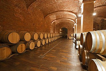
746-74708 - Gancia underground wine cathedral in Canelli, the barrels made by oak wood and named "barriques" where the wine is maturing, Asti, Piedmont, Italy, Europe
746-74691 - Contratto underground wine cathedral in Canelli, the barrels made by oak wood and named "barriques" where the wine is maturing, Asti, Piedmont, Italy
746-74680 - Bosca underground wine cathedral in Canelli, artistic composition named "la Piramide" by Eugenio Guglielminetti, Asti, Piedmont, Italy, Europe
746-67385 - A very old house of an herdsman named "Quile" restored, it is located in a place called "Sa Portiscra" in the Supramonte of Urzulei, Gennargentu and Orosei Gulf National Park, Sardinia, Italy, Europe
746-67386 - A very old house of an herdsman named "Quile" restored, it is located in a place called "Sa Portiscra" in the Supramonte of Urzulei, Gennargentu and Orosei Gulf National Park, Sardinia, Italy, Europe
808-1563 - Seven Sisters Waterfall, named for the seven separate streams that comprise it, Geirangerfjord, UNESCO World Heritage Site, Norway, Scandinavia, Europe
808-1564 - Seven Sisters Waterfall, named for the seven separate streams that comprise it, Geirangerfjord, UNESCO World Heritage Site, Norway, Scandinavia, Europe
857-90928 - A climber rappels down Cerro Fitz Roy's south face, with distant peaks and lakes of Argentine Patagonia in the distance. Cerro Fitz Roy is one of the most massive peaks in the Southern Andes, and is a sought after summit by the world's top alpinists. It was named in honor of the captain of Darwin's ship, the Beagle, Captain Robert FitzRoy, who explored the region. The indigenous name for the peak is Chalten, which means "smoking mountain". , Argentina
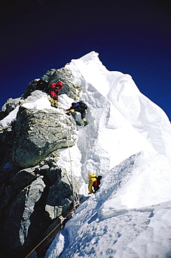
857-90580 - Mountaineers navigating through the Hillary Step on Mount Everest. The Hillary Step is a nearly vertical part (height around 40 ft) of upper Mount Everest. It lies almost at the top of the mountain, halfway from the "south summit" to the summit top, and is the last real challenge before the summit. It is reached by climbing the South East route. It was named after Sir Edmund Hillary, who was the first person, along with Tenzing Norgay, who passed it to reach the summit, Nepal
857-86752 - Exterior and courtyard views of Fort Frederik, now a tourist draw in Frederiksted, St, Croix. Built between 1752 and 1760 and now a historical museum, Fort Frederik was named the then reigning Danish monarch.
857-86744 - Exterior and courtyard views of Fort Frederik, now a tourist draw in Frederiksted, St, Croix. Built between 1752 and 1760 and now a historical museum, Fort Frederik was named the then reigning Danish monarch.
857-86753 - Exterior and seafront courtyard views of Fort Frederik, now a tourist draw in Frederiksted, St, Croix. Built between 1752 and 1760 and now a historical museum, Fort Frederik was named the then reigning Danish monarch.
911-10406 - The bizzarely named Zzyzx road in the Mojave desert, California, USA.
911-10212 - Thatcher Drive in Port Stanley, the capital of the Falkland Islands, named after Margaret Thatcher took the decision to liberate the Falklands after the Argentine invasion.
1113-97979 - Permanent resident on Little Palm Island, the great blue heron named Spencer, Little Palm Island Resort, Florida Keys, USA
797-10852 - England, Berkshire, Windsor, The Duchess of Cambridge pub re-named in 2011 was the first to be named after the newly married Kate.
797-10844 - England, East Sussex, Lewes, The annual bonfire night parade celebrating 17 protestant martyrs killed in the fifteen hundreds.
797-10845 - England, East Sussex, Lewes, The annual bonfire night parade celebrating 17 protestant martyrs killed in the fifteen hundreds.
797-10853 - England, Berkshire, Windsor, The Duchess of Cambridge pub re-named in 2011 was the first to be named after the newly married Kate.
797-12789 - Germany, Berlin, Mitte, memorial to an East German named Axel Hannamann killed trying to cross the Berlin Wall near the Brandenburg Gate on 5th June 1962 during the Cold War.
797-10854 - England, Berkshire, Windsor, The Duchess of Cambridge pub re-named in 2011 was the first to be named after the newly married Kate.
1112-2398 - Adult bottlenose dolphin (Tursiops truncates) affectionately named Fungie who has lived for decades near the Dingle Peninsula, County Kerry, Munster, Republic of Ireland, Europe
1112-2399 - Adult bottlenose dolphin (Tursiops truncates) affectionately named Fungie who has lived for decades near the Dingle Peninsula, County Kerry, Munster, Republic of Ireland, Europe
832-369845 - Visitors to the new 412-meter high observation deck Skydeck, Willis Tower, formerly named Sears Tower, Chicago, Illinois, United States of America, USA
832-342102 - Albatross as a figurehead of the Gorch Fock, sailing school ship of the German Navy, and the Swedish Schooner named Westkust, Hanse Sail 2008 in Warnemuende, Mecklenburg-Western Pomerania, Germany, Europe


