Recent searches
Loading...
1348-5416 - Color satellite image of Venice, Italy. Image collected on August 27, 2019 by Sentinel-2 satellites.
1348-5503 - Ice giant Uranus in space with moons concept panoramic
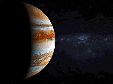
1348-5487 - Jupiter gas giant slowly orbiting in deep space concept panoramic. Some elements sourced from NASA public Domain.
1348-5458 - Color satellite image of Prudhoe Bay Oil Field, Alaska, United States. Image collected on July 02, 2020 by Sentinel-2 satellites.
1348-5417 - Color satellite image of Venice, Italy. Image collected on August 27, 2019 by Sentinel-2 satellites.
1348-5421 - Color satellite image of the indigenous territory Igarape Lage, Rondonia, Brazil, covering an area of 688,000 square kilometers. Image collected on September 25, 2020 by Sentinel-2 satellites.
1348-5506 - Strong sun flare hitting the Earths atmosphere concept panoramic. Some elements sourced from NASA public Domain.
1348-5415 - Color satellite image of Wuhan, the capital of Hubei Province, China. Image collected on September 22, 2019 by Sentinel-2 satellites.
1348-5518 - Sunrise in space over the planet Earth with a vibrant sun
1348-5450 - Color satellite image of Honolulu, Hawaii, United States. Image collected on May 05, 2020 by Sentinel-2 satellites.
1348-5489 - Jupiter gas giant slowly orbiting in deep space concept panoramic. Some elements sourced from NASA public Domain.
1348-5491 - gas giant Saturn with a bright sun orbiting in space concept panoramic. Some elements sourced from NASA public Domain.
1348-5457 - Color satellite image of Prudhoe Bay Oil Field, Alaska, United States. Image collected on July 02, 2020 by Sentinel-2 satellites.
1348-5426 - Color satellite image of crop circles in the desert in the Wadi As-Sirhan Basin, in Northern Saudi Arabia. Image collected on July 08, 2020 by Sentinel-2 satellites.
1348-5429 - Color satellite image of breakup of ice pack at the mouth of the Pine Island Glacier in Antarctica. This glacier is one of the most studied in Antarctica, as part of climate change monitoring. Image collected on January 31, 2019 by Sentinel-2 satellites.
1348-5483 - Sunrise over the planet Earth concept showing day and night with city lights panoramic over Europe. Some elements sourced from NASA public Domain.
1348-5464 - USA from space at night concept with street lights on panoramic. Some elements sourced from NASA public Domain.
1348-5501 - Gas giant Neptune with clouds and atmosphere concept panoramic
1348-5472 - Small moon orbiting a gas giant with storms and clouds
1348-5520 - Jupiter gas giant slowly orbiting in deep space concept
1348-5522 - gas giant Saturn with a bright sun orbiting in space concept
1348-5420 - Color satellite image of Tokyo, Capital city of Japan. Image collected on December 14, 2019 by Sentinel-2 satellites.
1348-5481 - Concept of large blue planet with two satellite moons orbiting and a distant blue star panoramic. Some elements sourced from NASA public Domain.
1348-5427 - Color satellite image of Port-au-Prince, Capital city of Haiti. Image collected on January 14, 2020 by Sentinel-2 satellites.
1348-5437 - Color satellite image of Haikou, Hainan, China. Image collected on June 21, 2020 by Sentinel-2 satellites.
1348-5486 - Sunrise over the planet mars orbiting in space with strong flare and shadows coming from a bright sun panoramic
1348-5453 - Color satellite image of wildfires in Sonoma County, California, United States. Image collected on October 27, 2019 by Sentinel-2 satellites.
1348-5466 - Sun, Earth and moon from space panoramic concept. Some elements sourced from NASA public Domain.
1348-5485 - Sunrise over the planet mars orbiting in space with strong flare and shadows coming from a bright sun panoramic
1348-5490 - Jupiter gas giant slowly orbiting in deep space concept panoramic. Some elements sourced from NASA public Domain.
1348-5525 - Dramatic sunrise over the gas giant Saturn illuminating the rings concept
1348-5482 - Polluted Earth concept with thick pollution as a haze covering the planet panoramic. Some elements sourced from NASA public Domain.
1348-3105 - Color satellite image of Mogadishu, capital city of Somalia. Image collected on March 01, 2017 by Sentinel-2 satellites.
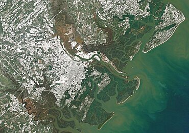
1348-3064 - Color satellite image of Savannah, Georgia, United States A powerful winter storm dropped snow over the city. Image collected on January 4, 2018 by Landsat 8 satellite.
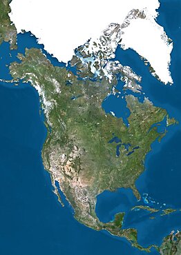
1348-3391 - Satellite view of North America. This image was compiled from data acquired by Landsat 7 & 8 satellites.
1348-5238 - Trinidad and Tobago, Satellite Image With Bump Effect, With Border
1348-3102 - Color satellite image of Baku, capital city of Azerbaijan. The city is situated on the western coast of the Caspian Sea. Image collected on September 13, 2017 by Sentinel-2 satellites.
1348-3360 - Satellite view of Svalbard, Norway. It is a Norwegian archipelago in the Arctic Ocean. This image was compiled from data acquired by Landsat satellites.
1348-3398 - Satellite view of Mauna Kea Volcano, Island of Hawaii. This image was compiled from data acquired by Landsat 8 satellite in 2014.
1348-3091 - Color satellite image of Singapore. Image collected on July 10, 2017 by Sentinel-2 satellites.
1348-3418 - Satellite view of Easter Island. This image was compiled from data acquired by Landsat 8 satellite in 2014.
1348-3086 - Color satellite image of Tallinn, capital city of Estonia. Image collected on September 05, 2017 by Sentinel-2 satellites.
1348-3356 - Satellite view of Tenerife, Canary Islands, Spain. It is the largest and most populous island of the seven Canary Islands. Volcano Mount Teide at center is the highest point of Spain, at 3718 m. This image was compiled from data acquired by Landsat 8 satellite in 2014.
1348-3363 - Satellite view of Sri Lanka. This image was compiled from data acquired by Landsat 8 satellite in 2014.
1348-3079 - Color satellite image of Doha, capital city of Qatar. Image collected on October 17, 2017 by Sentinel-2 satellites.
1348-3081 - Color satellite image of Kuwait City, capital city of Kuwait. Image collected on October 23, 2017 by Sentinel-2 satellites.
1348-3098 - Color satellite image of Ahmedabad, India. Image collected on October 30, 2017 by Sentinel-2 satellites.
1348-3056 - Satellite image of Hurricane Maria in 2017 over Puerto Rico. Image taken on September 21, 2017.
1348-3100 - Color satellite image of Shenzhen, China. It forms part of the Pearl River Delta megalopolis. Image collected on November 01, 2017 by Sentinel-2 satellites.
1348-3348 - Satellite view of British and US Virgin Islands. This image was compiled from data acquired by Landsat satellites.
1348-3053 - Color satellite image of Volcanoes on Kamchatka Peninsula, Russia. Klyuchevskaya, to the right, the tallest and most active volcano on the peninsula
1348-3390 - Satellite view of North America that shows Arctic ice cap. This image was compiled from data acquired by Landsat 7 & 8 satellites.
1348-3042 - Color satellite image of Jorge Montt Glacier, Patagonia, Chile on May 24, 2016. The fjord in front of Jorge Montt is choked with icebergs.
1348-3404 - Satellite view of the State of Hawaii, USA. The main islands are Kauai, Oahu, Maui and the Island of Hawaii. This image was compiled from data acquired by Landsat 8 satellite in 2014.
1348-3405 - Satellite view of the Island of Hawaii, USA. The island is formed of five volcanoes, Mauna Loa being the largest. This image was compiled from data acquired by Landsat 8 satellite in 2014.
1348-3051 - Satellite image of the Ganges River Delta, Bangladesh, India. Also known as the Brahmaputra Delta
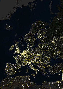
1348-4508 - Europe At Night With Country Borders, True Colour Satellite Image. True colour satellite image of Europe at night with country borders. This image in Lambert Conformal Conic projection was compiled from data acquired by LANDSAT 5 & 7 satellites.
1348-4498 - Globe Centred On The North Pole, True Colour Satellite Image
1348-3076 - Color satellite image of Abu Dhabi International Airport, United Arab Emirates. The amusement park Ferrari World Abu Dhabi is on Yas Island, at center left on the image. Image collected on September 21, 2017 by Sentinel-2 satellites.
1348-3406 - Satellite view of the Great Barrier Reef, Australia, off Mackay's coast. This image was compiled from data acquired in 2014 by Landsat 8 satellite.
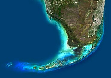
1348-3069 - Color satellite image of Southern Florida, United States. It shows Miami at east, Everglades National Park at center, and the Florida Keys at south. Image collected on January 06, 2017 by Sentinel-2 satellites.
1348-4506 - South America, True Colour Satellite Image. True colour satellite image of South America. This image in Lambert Azimuthal Equal Area projection was compiled from data acquired by LANDSAT 5 & 7 satellites.
1348-3040 - Color satellite image of Occidental Glacier, Patagonia, Chile on May 24, 2016.
1348-3420 - Satellite view of Crete, Greece. Crete is the largest and most populous of the Greek islands. This image was compiled from data acquired by Landsat 8 satellite in 2014.
1348-3371 - Satellite view of Northern Europe showing Scandinavia and the Baltic States. This image was compiled from data acquired by LANDSAT 7 & 8 satellites.
1348-3355 - Satellite view of Tongatapu, the largest island of Tonga archipelago. This image was compiled from data acquired by Landsat 8 satellite in 2014.
1348-3049 - Color satellite image of the Nile River, Egypt. The Nile Delta is formed in Northern Egypt where the Nile River spreads out and drains into the Mediterranean Sea. Images collected on October 1, 2017 by Landsat 8 satellite.
1348-3113 - Rattlesnake warning sign in Ballona Wetlands, Playa Vista, Los Angeles
1348-3387 - Satellite view of Northern South America. This image was compiled from data acquired by Landsat 7 & 8 satellites.
1348-3372 - Satellite view of Najran University, Saudi Arabia. This image was taken in 2014 by Landsat 8 satellite.
1348-3396 - Satellite view of Moorea, French Polynesia. This image was compiled from data acquired by Landsat 8 satellite in 2014.
1348-3392 - Satellite view of Mount Kilimanjaro, Tanzania. This dormant volcano is the highest mountain in Africa. It is part of the Kilimanjaro National Park. This image was compiled from data acquired by Landsat satellites.
1348-3386 - Satellite view of Nuku Hiva, the largest of the Marquesas Islands in French Polynesia. This image was compiled from data acquired by Landsat 8 satellite in 2014.
1348-3362 - Satellite view of Sulawesi, Indonesia. This image was compiled from data acquired by Landsat satellites.
1348-3046 - Color satellite image of Lake Michigan, United States. Image collected on May 1, 2016 by Landsat 8 satellite.
1348-3440 - Satellite view of Syr Daria River, Kazakhstan. This image was compiled from data acquired in 2014 by Landsat 8 satellite.
1348-3374 - Satellite view of Sao Tome. This image was compiled from data acquired by Landsat satellites.
1348-3394 - Satellite view of Eruption at Mount Etna, Sicily. This image was taken on December 3, 2015 by Landsat 8 satellite.
1348-3074 - Color satellite image of Chicago, Illinois, United States. The city is located at the south western tip of Lake Michigan. Image collected on October 08, 2017 by Sentinel-2 satellites.
1348-3429 - Satellite view of the Abaco Islands that lie in the northern Bahamas
1348-5297 - Seasons change because more direct sunlight falls on some parts of Earth than others at different times of the year.
1348-3361 - Satellite view of Super Typhoon Phanfone in 2015 approaching Japan. Image taken on October 3, 2014.
1348-4495 - Globe Showing Northern America, True Colour Satellite Image. True colour satellite image of the Earth showing Northern America, half in shadow. This image in orthographic projection was compiled from data acquired by LANDSAT 5 & 7 satellites.
1348-3047 - Color satellite image of Lake Huron, North America. Image collected on May 1, 2016 by Landsat 8 satellite.
1348-3365 - Satellite view of the Southern Great Barrier Reef and Fraser Island along Queensland's coastline in north-east Australia. This image was compiled from data acquired in 2014 by Landsat 8 satellite.
1348-3070 - Color satellite image of New Orleans, Louisiana, United States. The city is located in the Mississippi River Delta, south of Lake Pontchartrain, on the banks of the Mississippi River. Image collected on February 10, 2017 by Sentinel-2 satellites.
1348-3375 - Satellite view of Sao Miguel Island, Azores, Portugal. It is the largest and most populous island in the Azores archipelago. This image was compiled from data acquired by Landsat satellites.
1348-3397 - Satellite view of the Middle East. This image was compiled from data acquired in 2014 by Landsat 8 satellite.
1348-3383 - Satellite view of Pico Island, Azores, Portugal. Volcano Mount Pico, to the West, is the highest point in Portugal, at 2351 m, and the most famous landmark in the Azores. This image was compiled from data acquired by Landsat satellites.
1348-3347 - Satellite view of Viti Levu Island, Fiji. This is the largest island in the Republic of Fiji and the site of the nation's capital, Suva. This image was compiled from data acquired by Landsat 8 satellite in 2014.
1348-3368 - Satellite view of South America. This image was compiled from data acquired by Landsat 7 & 8 satellites.
1348-3413 - Satellite view of the Fiji Islands. This image was compiled from data acquired by Landsat 8 satellite in 2014.
1348-3410 - Satellite view of Funafuti, an atoll on which the capital of the island nation of Tuvalu is located. This image was compiled from data acquired by Landsat 8 satellite in 2014.
1348-3089 - Color satellite image of Port-au-Prince, capital city of Haiti. Image collected on March 25, 2017 by Sentinel-2 satellites.
1348-3054 - Satellite image of Hurricane Irma in 2017 over the Caribbean at night. Image taken on September 5, 2017.


