Recent searches
Loading...
1348-5452 - Color satellite image of wildfires in Sonoma County, California, United States. Image collected on October 27, 2019 by Sentinel-2 satellites.
1348-5440 - Color satellite image of Conakry, Capital city of Guinea. Image collected on December 28, 2019 by Sentinel-2 satellites.
1348-5432 - Color satellite image of Mecca, Saudi Arabia. Image collected on August 05, 2019 by Sentinel-2 satellites.
1348-5424 - Color satellite image of Tashkent, Capital city of Uzbekistan. Image collected on July 26, 2019 by Sentinel-2 satellites.
1348-5449 - Color satellite image of Honolulu, Hawaii, United States. Image collected on May 05, 2020 by Sentinel-2 satellites.
1348-5439 - Color satellite image of Gibraltar, United Kingdom. Image collected on August 20, 2019 by Sentinel-2 satellites.
1348-5414 - Color satellite image of Yangon, Myanmar. Image collected on December 14, 2019 by Sentinel-2 satellites.
1348-5435 - Color satellite image of Ho Chi Minh City, Vietnam. Image collected on February 22, 2020 by Sentinel-2 satellites.
1348-5451 - Color satellite image of St. Petersburg, Florida, United States. Image collected on May 08, 2020 by Sentinel-2 satellites.
1348-5434 - Color satellite image of Juba, Capital city of South Sudan. Image collected on December 04, 2019 by Sentinel-2 satellites.
1348-5456 - Color satellite image of Prudhoe Bay Oil Field, Alaska, United States. Image collected on July 02, 2020 by Sentinel-2 satellites.
1348-5446 - Color satellite image of Lincoln, Nebraska, United States. Image collected on June 03, 2020 by Sentinel-2 satellites.
1348-5423 - Color satellite image of Tbilisi, Capital city of Georgia. Image collected on October 29, 2018 by Sentinel-2 satellites.
1348-5419 - Color satellite image of Tokyo, Capital city of Japan. Image collected on December 14, 2019 by Sentinel-2 satellites.
1348-5454 - Color satellite image of Victoria, British Columbia, Canada. Image collected on August 04, 2019 by Sentinel-2 satellites.
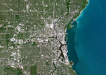
1348-5444 - Color satellite image of Milwaukee, Wisconsin, United States. Image collected on June 14, 2020 by Sentinel-2 satellites.
1348-5448 - Color satellite image of Detroit, Michigan, United States. Image collected on June 18, 2020 by Sentinel-2 satellites.
1348-5436 - Color satellite image of Haikou, Hainan, China. Image collected on June 21, 2020 by Sentinel-2 satellites.
1348-5430 - Color satellite image of Noor Ouarzazate Solar Complex and Ouarzazate, Morocco. It is the largest concentrated solar power plant in the world. Image collected on July 10, 2020 by Sentinel-2 satellites.
1348-5425 - Color satellite image of Shantou, China. Image collected on November 18, 2019 by Sentinel-2 satellites.
1348-5442 - Color satellite image of Bhadla Solar Park, Jodhpur District, Rajasthan, India. Image collected on June 29, 2020 by Sentinel-2 satellites.
1348-5441 - Color satellite image of Chennai, India. Image collected on June 15, 2019 by Sentinel-2 satellites.
1348-5422 - Color satellite image of Tbilisi, Capital city of Georgia. Image collected on October 29, 2018 by Sentinel-2 satellites.
1348-5445 - Color satellite image of Milwaukee, Wisconsin, United States. Image collected on June 14, 2020 by Sentinel-2 satellites.
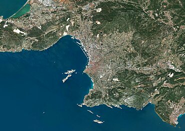
1348-5433 - Color satellite image of Marseille, France. Image collected on July 29, 2019 by Sentinel-2 satellites.
1348-5418 - Color satellite image of deforestation inthe State of Para, Brazil, around the town Ruropolis. Image collected on August 14, 2020 by Sentinel-2 satellites.
1348-5438 - Color satellite image of Haikou Bay and Nanhai Pearl Artificial Island, Hainan, China. Image collected on June 21, 2020 by Sentinel-2 satellites.
1348-5443 - Color satellite image of bushfires in Batemans Bay on the South Coast region of New South Wales, Australia. Image collected on December 31, 2019 by Sentinel-2 satellites.
1348-5428 - Color satellite image of ice pack at the mouth of Pine Island Glacier in Antarctica. This glacier is one of the most studied in Antarctica, as part of climate change monitoring. Image collected on March 07, 2018 by Sentinel-2 satellites.
1348-5431 - Color satellite image of Mombassa, Kenya. Image collected on September 03, 2017 by Sentinel-2 satellites.
1348-5413 - Color satellite image of Tengger Desert Solar Park in Zhongwei, Ningxia, China. Image collected on June 28, 2020 by Sentinel-2 satellites.
1348-5447 - Color satellite image of Detroit, Michigan, United States. Image collected on June 18, 2020 by Sentinel-2 satellites.
1348-5455 - Color satellite image of Victoria, British Columbia, Canada. Image collected on August 04, 2019 by Sentinel-2 satellites.
1348-5416 - Color satellite image of Venice, Italy. Image collected on August 27, 2019 by Sentinel-2 satellites.
1348-5458 - Color satellite image of Prudhoe Bay Oil Field, Alaska, United States. Image collected on July 02, 2020 by Sentinel-2 satellites.
1348-5417 - Color satellite image of Venice, Italy. Image collected on August 27, 2019 by Sentinel-2 satellites.
1348-5421 - Color satellite image of the indigenous territory Igarape Lage, Rondonia, Brazil, covering an area of 688,000 square kilometers. Image collected on September 25, 2020 by Sentinel-2 satellites.
1348-5415 - Color satellite image of Wuhan, the capital of Hubei Province, China. Image collected on September 22, 2019 by Sentinel-2 satellites.
1348-5450 - Color satellite image of Honolulu, Hawaii, United States. Image collected on May 05, 2020 by Sentinel-2 satellites.
1348-5457 - Color satellite image of Prudhoe Bay Oil Field, Alaska, United States. Image collected on July 02, 2020 by Sentinel-2 satellites.
1348-5426 - Color satellite image of crop circles in the desert in the Wadi As-Sirhan Basin, in Northern Saudi Arabia. Image collected on July 08, 2020 by Sentinel-2 satellites.
1348-5429 - Color satellite image of breakup of ice pack at the mouth of the Pine Island Glacier in Antarctica. This glacier is one of the most studied in Antarctica, as part of climate change monitoring. Image collected on January 31, 2019 by Sentinel-2 satellites.
1348-5420 - Color satellite image of Tokyo, Capital city of Japan. Image collected on December 14, 2019 by Sentinel-2 satellites.
1348-5427 - Color satellite image of Port-au-Prince, Capital city of Haiti. Image collected on January 14, 2020 by Sentinel-2 satellites.
1348-5437 - Color satellite image of Haikou, Hainan, China. Image collected on June 21, 2020 by Sentinel-2 satellites.
1348-5453 - Color satellite image of wildfires in Sonoma County, California, United States. Image collected on October 27, 2019 by Sentinel-2 satellites.
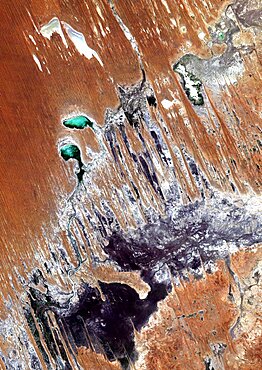
1348-4582 - Simpson Desert , Australia, True Colour Satellite Image. True colour satellite image of the Simpson Desert in the Australian Outback. The sand dunes are coloured in red because of iron oxyd. The green areas are lakes and oueds. East is a calcareous plateau. Image taken on 29 July 1992 using LANDSAT data.
1348-4600 - Barcelona, Spain, True Colour Satellite Image. Barcelona, Spain. True colour satellite image of Barcelona, taken on 10 August 2000, using LANDSAT 7 data.
1348-4587 - Pine Island Bay, Amundsen Sea, Antarctica, True Colour Satellite Image. True colour satellite of Pine Island Bay in the Amundsen Sea.The blakek mark crossing the image shows the limit between the indlansis of the Wallgreen coast and Pine Island Bay in Amundsen Sea, in the Western part of Antarctica. Image taken on 13 January 2001 using LANDSAT data.
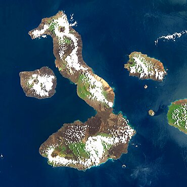
1348-4557 - Galapagos Volcanoes, Ecuador, True Colour Satellite Image. Galapagos Archipelago, Ecuador, true colour satellite image. Galapagos Archipelago is situated 1000 km West of the Ecuadorian coast. The largest and most volcanically active island in the archipelago is Isabela (6 volcanoes). On the left of image, the island of Fernandina (one volcano). Image taken on 16 March 2001 using LANDSAT data. Print size 30 x 30 cm.
1348-4573 - Easter Island, Chile, True Colour Satellite Image. Satellite image of Easter Island or Rapa Nui, territory of Chile, is an isolated island in the South Pacific ocean, West of Chile.The image used LANDSAT data.
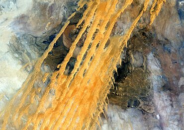
1348-4580 - Desert Erg Iguidi, Algeria, True Colour Satellite Image. True colour satellite image of Erg Iguidi, a sand desert between Algeria and Mauritania. The 250m wide dunes lay in the South on a sand plain, and in the North on a blakek sandstone area. The light blue areas are calcareous and salt crusts left out from the evaporation of the oueds' water. Image taken on 29 March 1987 using LANDSAT data.
1348-4590 - Bazaruto Archipelago, Mozambique, True Colour Satellite Image. True colour satellite image of sand islands of Bazaruto Archipelago off the Mozambique coast. Image taken on 21 April 1989 using LANDSAT data.
1348-4569 - Dead Sea, Israel, Jordan, True Colour Satellite Image. The Dead Sea, Israel, Jordan, true colour satellite image. The Dead Sea and sedimentation tanks in turquoise. Image taken on 14 August 1987 using LANDSAT data.
1348-4559 - Augustine Volcano, Alaska, Usa, True Colour Satellite Image. Augustine Volcano, Alaska, true colour satellite image. Augustine is a volcano 1227 m high conical-shaped island stratovolcano located in Alaska's Cook Inlet. Image taken on 16 August 2000 using LANDSAT data. Print size 30 x 30 cm.
1348-4598 - Dublin, Ireland, True Colour Satellite Image. Dublin, Republic of Ireland. True colour satellite image of Dublin, capital city of the Republic of Ireland. Composite of 2 image taken on 1st & 24 May 2001, using LANDSAT 7 data.
1348-3105 - Color satellite image of Mogadishu, capital city of Somalia. Image collected on March 01, 2017 by Sentinel-2 satellites.
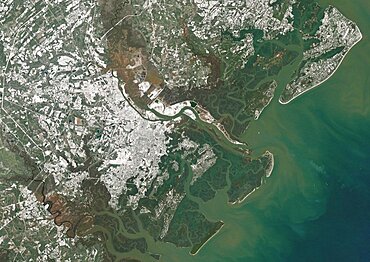
1348-3064 - Color satellite image of Savannah, Georgia, United States A powerful winter storm dropped snow over the city. Image collected on January 4, 2018 by Landsat 8 satellite.
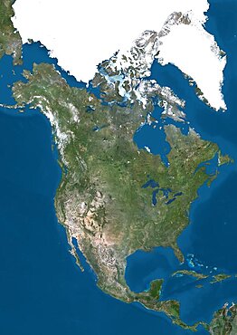
1348-3391 - Satellite view of North America. This image was compiled from data acquired by Landsat 7 & 8 satellites.
1348-5238 - Trinidad and Tobago, Satellite Image With Bump Effect, With Border
1348-3102 - Color satellite image of Baku, capital city of Azerbaijan. The city is situated on the western coast of the Caspian Sea. Image collected on September 13, 2017 by Sentinel-2 satellites.
1348-4480 - Hurricane Katrina, Louisiana, Us, On 28/08/2005, True Colour Satellite Image. Hurricane Katrina on 28 August 2005 near peak strength over the Gulf of Mexico. True-colour satellite image using MODIS data.
1348-4472 - Balearic Islands, Spain, True Colour Satellite Image
1348-3360 - Satellite view of Svalbard, Norway. It is a Norwegian archipelago in the Arctic Ocean. This image was compiled from data acquired by Landsat satellites.
1348-3398 - Satellite view of Mauna Kea Volcano, Island of Hawaii. This image was compiled from data acquired by Landsat 8 satellite in 2014.
1348-3091 - Color satellite image of Singapore. Image collected on July 10, 2017 by Sentinel-2 satellites.
1348-3418 - Satellite view of Easter Island. This image was compiled from data acquired by Landsat 8 satellite in 2014.
1348-3086 - Color satellite image of Tallinn, capital city of Estonia. Image collected on September 05, 2017 by Sentinel-2 satellites.
1348-3356 - Satellite view of Tenerife, Canary Islands, Spain. It is the largest and most populous island of the seven Canary Islands. Volcano Mount Teide at center is the highest point of Spain, at 3718 m. This image was compiled from data acquired by Landsat 8 satellite in 2014.
1348-3363 - Satellite view of Sri Lanka. This image was compiled from data acquired by Landsat 8 satellite in 2014.
1348-3079 - Color satellite image of Doha, capital city of Qatar. Image collected on October 17, 2017 by Sentinel-2 satellites.
1348-4541 - Meteor Impact Crater In The Libyan Desert, Egypt, True Colour Satellite Image. True colour satellite image of an impact structure in the Libyan desert, Egypt. Image taken on 9 November 1986 using LANDSAT data.
1348-4612 - Middle East, True Colour Satellite Image. Middle East, true colour satellite image
1348-4537 - Siljan Meteor Impact Crater, Sweden, True Colour Satellite Image. True colour satellite image of Siljan impact structure, Sweden (diameter : 55 km). Image using LANDSAT data.
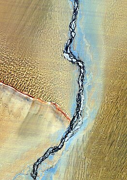
1348-4581 - Takla-Makan Desert, Xinjiang, China, True Colour Satellite Image. True colour satellite image of the Takla-Makan desert in the Xinjiang province, with the river Yurungkax. Image taken on 5 October 1990 using LANDSAT data.
1348-3081 - Color satellite image of Kuwait City, capital city of Kuwait. Image collected on October 23, 2017 by Sentinel-2 satellites.
1348-3098 - Color satellite image of Ahmedabad, India. Image collected on October 30, 2017 by Sentinel-2 satellites.
1348-4552 - Unzen Volcano In 2001, Japan, True Colour Satellite Image
1348-3056 - Satellite image of Hurricane Maria in 2017 over Puerto Rico. Image taken on September 21, 2017.
1348-3100 - Color satellite image of Shenzhen, China. It forms part of the Pearl River Delta megalopolis. Image collected on November 01, 2017 by Sentinel-2 satellites.
1348-3348 - Satellite view of British and US Virgin Islands. This image was compiled from data acquired by Landsat satellites.
1348-3053 - Color satellite image of Volcanoes on Kamchatka Peninsula, Russia. Klyuchevskaya, to the right, the tallest and most active volcano on the peninsula
1348-4459 - Ural Delta, Kazakhstan, True Colour Satellite Image. True colour satellite image of the Ural Delta in Kazakhstan. The Ural River ends at the Caspian Sea. Composite image using LANDSAT 5 data.
1348-3390 - Satellite view of North America that shows Arctic ice cap. This image was compiled from data acquired by Landsat 7 & 8 satellites.
1348-3042 - Color satellite image of Jorge Montt Glacier, Patagonia, Chile on May 24, 2016. The fjord in front of Jorge Montt is choked with icebergs.
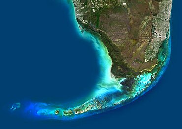
1348-4577 - Everglades, Florida, Usa, True Colour Satellite Image. Satellite image of the Everglades
1348-3404 - Satellite view of the State of Hawaii, USA. The main islands are Kauai, Oahu, Maui and the Island of Hawaii. This image was compiled from data acquired by Landsat 8 satellite in 2014.
1348-3405 - Satellite view of the Island of Hawaii, USA. The island is formed of five volcanoes, Mauna Loa being the largest. This image was compiled from data acquired by Landsat 8 satellite in 2014.
1348-3051 - Satellite image of the Ganges River Delta, Bangladesh, India. Also known as the Brahmaputra Delta
1348-4528 - Finland, Europe, True Colour Satellite Image With Border. Satellite view of Finland (with border). This image was compiled from data acquired by LANDSAT 5 & 7 satellites.
1348-4540 - Kara-Kul Meteor Impact Crater, Tajikistan, True Colour Satellite Image. True colour satellite image of Kara-Kul impact structure, Tajikistan (age : 25 million years ; diameter : 52 km). Image taken on 27 September 1992 using LANDSAT data.
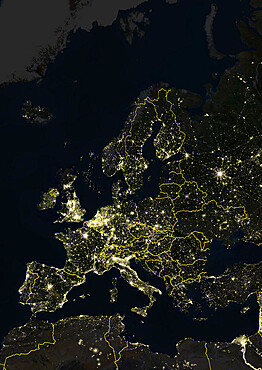
1348-4508 - Europe At Night With Country Borders, True Colour Satellite Image. True colour satellite image of Europe at night with country borders. This image in Lambert Conformal Conic projection was compiled from data acquired by LANDSAT 5 & 7 satellites.
1348-4618 - Globe Asia, True Colour Satellite Image. Earth. True colour satellite image of the Earth, centred on Asia
1348-4498 - Globe Centred On The North Pole, True Colour Satellite Image
1348-3076 - Color satellite image of Abu Dhabi International Airport, United Arab Emirates. The amusement park Ferrari World Abu Dhabi is on Yas Island, at center left on the image. Image collected on September 21, 2017 by Sentinel-2 satellites.
1348-4609 - New Zealand, True Colour Satellite Image. New Zealand, true colour satellite image. This image was compiled from data acquired by LANDSAT 5 & 7 satellites.
1348-3406 - Satellite view of the Great Barrier Reef, Australia, off Mackay's coast. This image was compiled from data acquired in 2014 by Landsat 8 satellite.
1348-4616 - Globe Africa, True Colour Satellite Image. Earth. True colour satellite image of the Earth, centred on Africa
1348-3069 - Color satellite image of Southern Florida, United States. It shows Miami at east, Everglades National Park at center, and the Florida Keys at south. Image collected on January 06, 2017 by Sentinel-2 satellites.
1348-4483 - Cyclone Gafilo, Indian Ocean, In 2004, True Colour Satellite Image. Tropical Cyclone Gafilo over the Indian Ocean, Northwest of Madagascar, on 6 March 2004. True-colour satellite image using MODIS data.


